 AVW
AVW Avira Resources Limited (ASX: AVW) (Avira or the Company) has five exploration licenses in the Ashburton Basin, Western Australia (the Wyloo Project) to explore for epithermal gold, silver and copper.
The Wyloo Project consists of 5 exploration licenses (E08/3329, E08/2230, E08/3321, E08/3332, E08/3333).
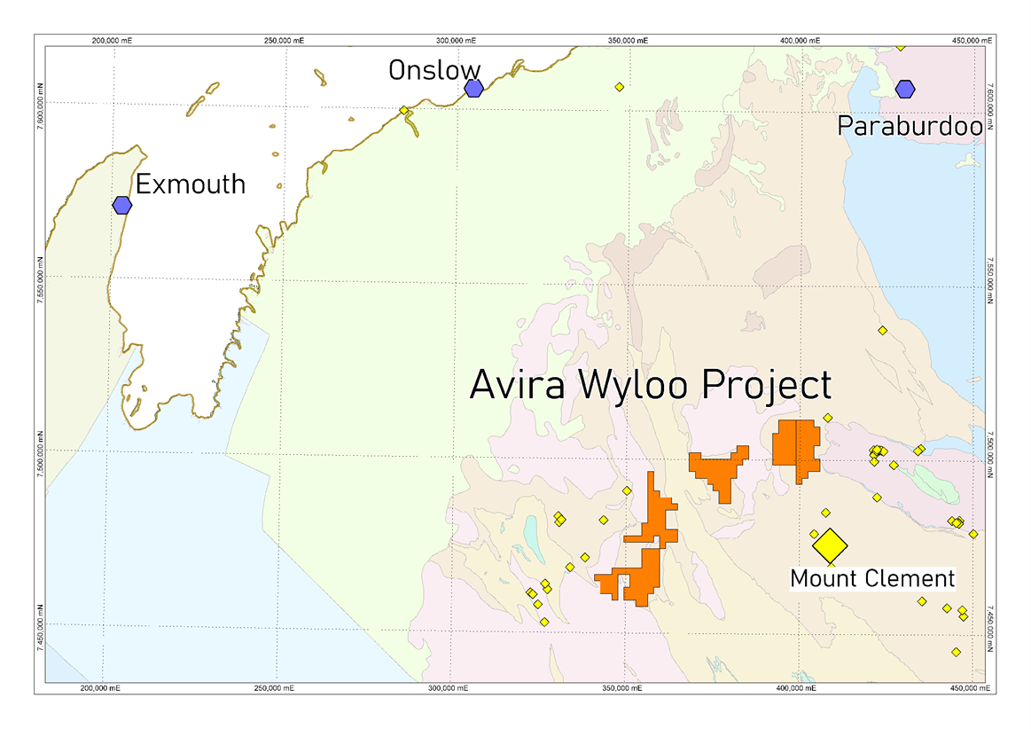
Figure 1. Location of Avira’s Wyloo copper/gold Project
Mount Clement Gold Deposit – Epithermal Au-Ag-Cu Mineralisation
The Mount Clement gold deposit is a small occurrence of gold hosted within the Ashburton Basin, Western Australia.
Mineralisation at Mount Clement occurs in a ~600-700m long, 200-300m thick section of the Wyloo Group sediments, on the north side of a hill. The deposit is hosted within metamorphosed calcareous and silicilastic rocks (shale, carbonate, dolomite, mudstone, sandstone), and chert (hydrothermal exhalate), forming an exhalite mound (figure 2).
Mt Clement has recently been mapped and described by the Geological Survey of Western Australia as syngenetic and epithermal. The GSWA interpretation is that the deposit formed roughly synchronous with the Wyloo Group sedimentation at ~1828Ma, with the intrusion of the Moorarie Suite granitoids from c. 1830-1798Ma. The genetic model preferred for the Mt Clement Au-Cu-Ag deposit is that of hydrothermal fluids flowing up syn-sedimentary faults, and depositing gold in exhalative carbonate-chert-pyrite within the subsurface of the sediments.
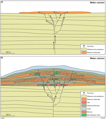
Figure 2 Mount Clement Gold Deposit ore genetic model (GSWA, 2021)
Another implication is that this represents one end-member of granite-associated mineralizing processes within the Wyloo Group during the intrusion of the Moorarie Suite. Other examples of granite-associated epigenetic mineralization includes skarn and VMS type mineralization, such as tungsten skarns at Mount Alexander (Kimber Well), and VMS hosted within felsic volcaniclastic sediments throughout the Wyloo Group.
Gneiss Results, Avira’s consultant, identified prospective geology ‘search space’ within the Ashburton Basin being defined by the Wyloo Group sediments which are within 5km of Moorarie Suite granites. This forms a halo of prospective ground surrounding Moorarie Suite granites within the north of the Gascoyne Province (figure 3). Gneiss Results identified several areas located in open ground which have been applied for under five exploration licenses.
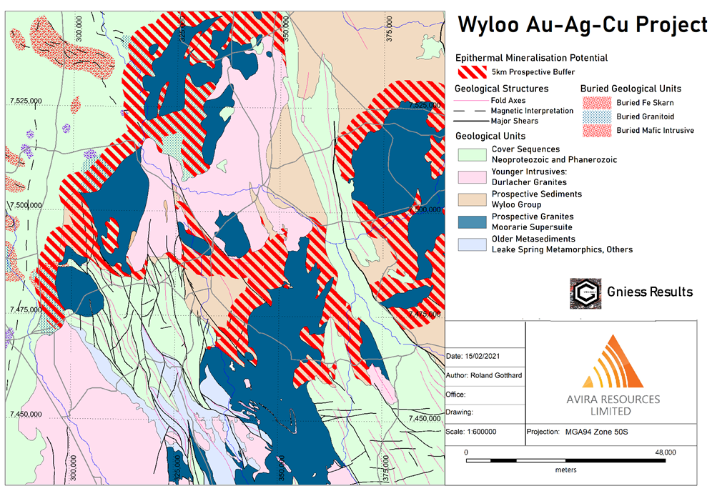
Figure 3: Prospective 5km corridor surrounding Moorarie/Wyloo Contact
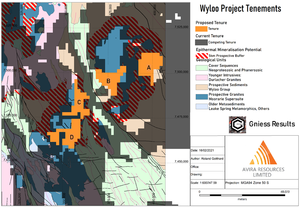
Figure 4: Open Ground Applied for under five exploration licences by Avira Resources.
Area A. Exploration licences E08/3329 (Tajeri Bore) and E08/3330 (Mount Edith)
These tenements cover 26 and 32 sub-blocks, respectively, for a combined area of 155km2. The tenement overlies an area of the Wyloo Group within the prospective 5 kilometre prospectivity halo, covered by alluvium, colluvium and sheetwash. Initial interpretation of regional magnetic surveys shows a series of north-east and north0west striking structures within a zone of constriction between low-magnetic granitoids.
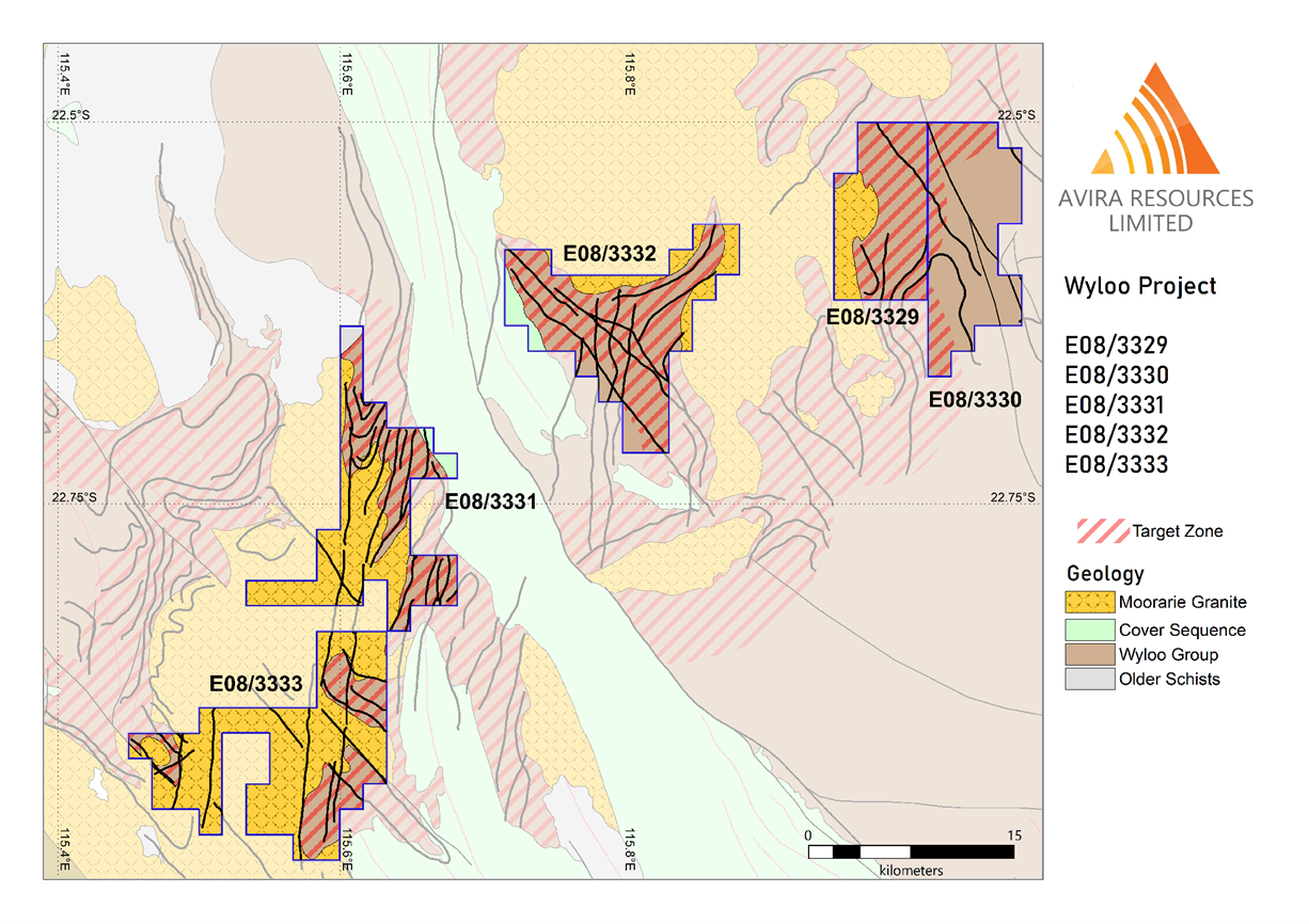
Area B: Exploration licence E08/3331 (Gilba Bore)
This tenement consists of 39 sub-blocks over an area of 123km2 and covers a 21km strike of Wyloo Group sediments which are within 5 kilometres of Moorarie Granite. Preliminary interpretation of magnetic and geological mapping has been undertaken, showing Wyloo Group sediments are underlain and interfinger with Moorarie Granitoids. A series of faults transect the area, and are associated with magnetic anomalies. The interpretation is that these magnetic anomalies are possibly related to skarnification and alteration.
The tenement is mostly unexplored, with limited prospecting and sampling undertaken in the 1950-1980 period. Avira is compiling the historical exploration information on this tenement.
Area C: Exploration licence E08/3332 (Mount Price)
This tenement covers 43 sub-blocks and 135km2. The tenement covers a 16 kilometre strike of contact between a Moorarie Granite intrusion and the enclosing Wyloo Group metasediments. The granite contact is magnetically anomalous compared to other areas, possibly representing skarnification and alteration. The area has little past exploration and no systematic rock chip, stream or sediment sampling.
The remainder of the tenement covers a NW trending structural corridor which is mostly within the 5 kilometre prospective zone, and could potentially represent alteration/skarnification and growth faults capable of hosting epithermal mineralization. Magnetic lows may represent smaller masses of prospective granite at depth.
Area D: Exploration licence E08/3333 (Thowagee Well).
This tenement consists of 39 sub-blocks for 155km2, covering a 17km strike of Wyloo Group sediments which lie within 5 kilometres of Moorarie Suite Granites in two zones, on the east and west of the tenure, and mixed granite-gabbro remnants within the Moorarie Suite in the centre of the tenure. The area is generally well exposed, with lateritised colluvium shallowly covering granitoid and metasediments. There has been regional scale stream sediment sampling over the western prospective area, which has shown low-level anomalism in several elements, but the east is not well explored. Avira is undertaking data compilation.
